

The Fourth of July celebration of America’s independence always gets me thinking of the history of the USA. In honor of the historical day, I took the boys to the Treaty Tree and Mile Post Zero. This site commemorates Captain Thomas Cram placing the first survey marker establishing the Wisconsin-Michigan border in 1841. That is one of the things I like about the USA is the federal system of government. Much of governance is left to the states and every state has its quirks and local customs.When states were being carved out of the Northwest Ordinance of 1787, there was a dispute between the states of Ohio and Michigan regarding its borders. Most of the problem was poor surveying. If this happened today, GPS would accurately define borders. Because of mistakes made by surveyors and early map makers, both sides claimed the Toledo Strip, the narrow green area in the picture below. The strip of land had the port city of Toledo, the Maumee River and farmlands to the west. The state militias intimidated each other across the river but never started fighting over the strip of land. (see Toledo War).

The dispute was resolved because then President Andrew Jackson needed Ohio’s electoral votes. He made a compromise, giving Ohio the Toledo Strip (500 square miles) and giving Michigan the western side of the Upper Peninsula (16,000 square miles) and statehood. At the time they were not happy, but as a Michigander, I think it was a good deal. I graduated from Adrian College which is located in the far southeast corner of Michigan, very near to the Toledo Strip. The city of Toledo is not a picturesque city and the huge amount of land (the UP is the size of Switzerland) makes Michigan the largest state in area east of the Mississippi. I see where Wisconsin would complain they lost the UP but they were not powerful enough as a territory to weigh in on the decision.
Today the Michigan border counties (Gogebic, Iron, Dickinson, Menominee) share the Central time zone with Wisconsin and many cultural similarities. We are a mix of Wisconsin and Michigan influences are the Western UP is probably more similar to northern Wisconsin than Michigan’s Lower Peninsula. The city of Green Bay, Wisconsin is the unofficial “capital” of the UP. The most important city in the UP is Marquette.
Getting back to Captain Cram, the US government thought that they could use rivers to separate the Upper Peninsula from Wisconsin. This mostly works with the Menominee and Brule Rivers emptying into Lake Michigan. However, there is a gap from where the Brule River starts at Brule Lake to where the Montreal River empties into Lake Superior. Cram’s job was to draw a straight line between the two spots. The Treaty Tree marks the start of this line at the headwaters of the Brule River. Surveyors often carved into trees to mark special spots and that is exactly what Cram did. The Tamarack tree he chose is dead and preserved at a museum in Marquette. As you can read below, the idea of land ownership and precisely defining state borders was lost on the Ojibwa (Chippewa) indigenous people of the time. I don’t think future surveyors left gifts for them at the site. Cram sent his report to Congress and the border was redefined. Instead of rivers separating the two states, a section would be a land border.

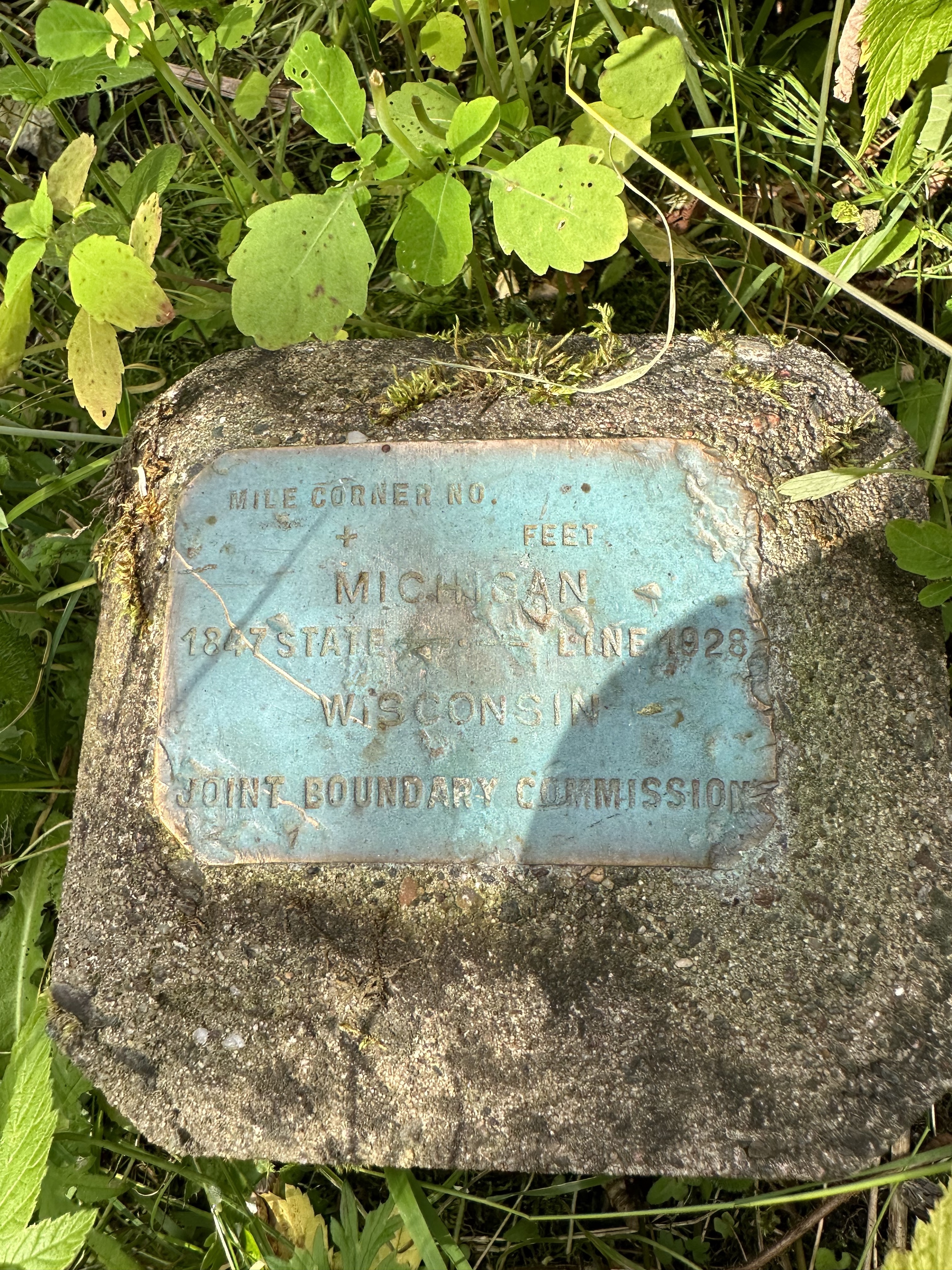
William A. Burt came back in 1847 to make it official and a monument is in place marking “Mile Zero”, which is the start of the land border between the Brule River, going to Lac View Desert and continuing to the Montreal River and eventually Lake Superior. In 1928 a Joint Border Commission put in the plaque below. The site is maintained today near a state campground. We had to clear some vines that were covering the marker.
We finished the day by watching the City of Iron River fireworks show. The fireworks were literally over our heads because we were about 50 meters from where the Iron River Fire Department was shooting from. It was a great way to end the day and to celebrate 247 years of the United States of America.
