Hiking the Sturgeon River Gorge Wilderness – June 23, 2024

Beau and Oliver on the Sturgeon River

The United States Forest Service oversees the National Wilderness Preservation System. The program protects 803 designated Wilderness Areas that cover 111.7 million acres of land (larger than the state of California). American President Lyndon B. Johnson signed the 1964 Wilderness Act to preserve “an enduring resource of wilderness” for future generations. Americans have greatly altered nature and I am heartened that at least a small portion of the land is preserved.

On Sunday I took my son Oliver and my two nephews, Beau and Tony, to visit one of the 803 wilderness areas, the Sturgeon River Gorge Wilderness Area. It is only an hour’s drive from my home and I can’t believe I’ve never been there. It is stunningly beautiful! The interior of the Upper Peninsula of Michigan is rarely visited by tourists. It is not the easiest place to get to with two-track ATV trails and narrow gravel roads being the only access. We had the place to ourselves on a sunny Sunday June afternoon! It is located almost directly north of my village of Caspian in southern Houghton C0unty. In looking at the map, I could easily ride my bicycle to the campground, taking all forest roads.

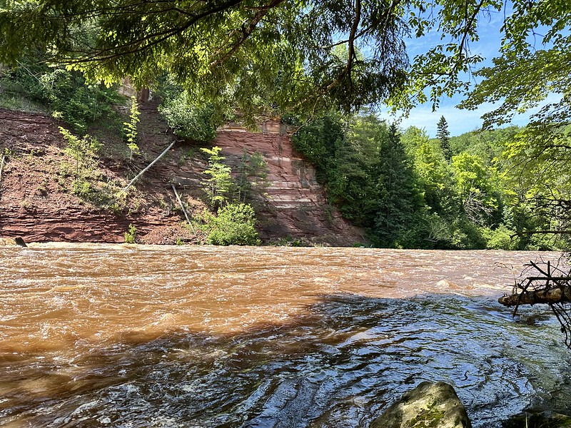
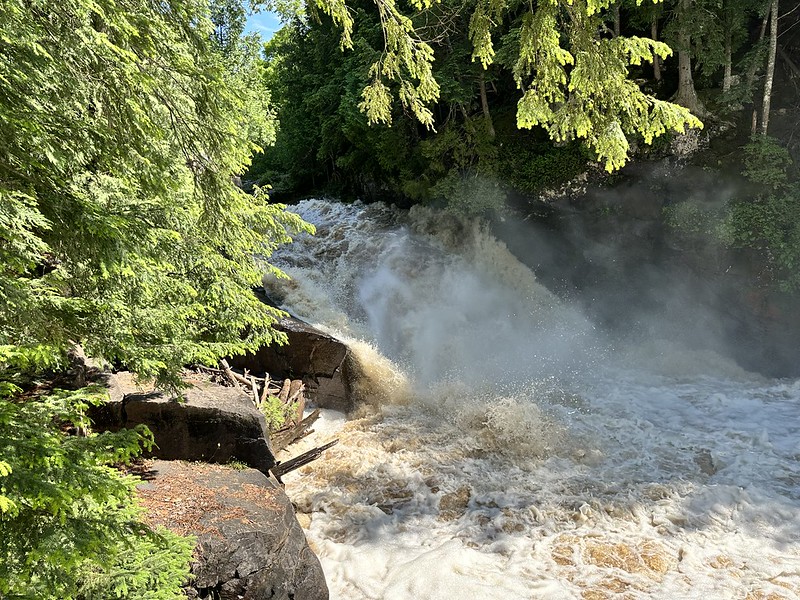
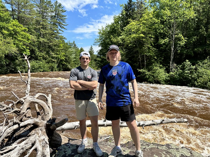
We started at the Sturgeon River Falls trail head. The 1-mile trail is well-marked and runs along the top of the gorge for a short distance before a series of switchback trails leads hikers to the river bank. The wide gorge is approximately 300 feet deep and covered with beautiful trees. It had rained the day before the river was roaring. It looked like a wild version of Willy Wonka’s Chocolate River. The rivers of the Upper Peninsula are brown-colored from the tannins (plant chemicals) from the surrounding forests, especially cedar marshland. The water was not muddy or silty and looked like chocolate in the UP sunshine. The power of rapids exploding through the narrow bedrock was breathtaking. I don’t think one could kayak through it.

The Boys at the Bears Den Overlook

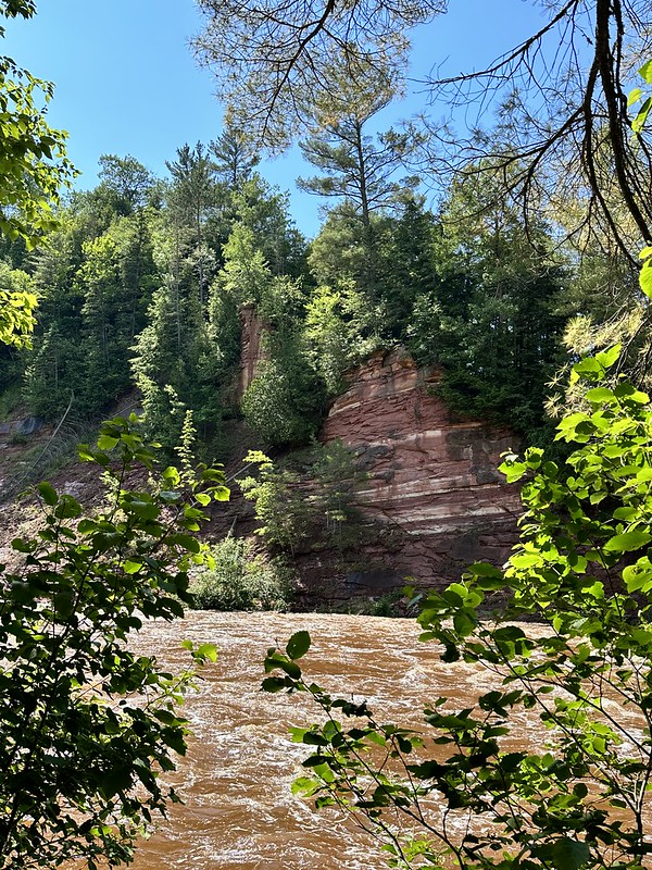
On the way back home we stopped at the Bears Den Overlook, another short trail. With so many trees in the UP it is rare to get long views over the forests. The view over the gorge was awesome and worth the stop. We worked our way about halfway down along a narrow ridge to the right of the overlook before returning to the car. You can see the chocolate ribbon of the river at the bottom of the gorge from the top. I will definitely come back and explore more of the area. The next time I come I will set up a camp at the Sturgeon River Campground, hike the Sidnaw Trail, and ride bicycles up to the falls and overlook and explore a bit more of the area.

Beldersoy Mountain Climb

Oliver resting with Beldersoy Ski Resort Piste in the background

This past Sunday, Owen, Oliver and I went hiking in the Ugam-Chatkal National Park. This was my second visit to the park and we were led by the famous guide Boris. The Chatkal Range, part of the western Tian Shan Mountains, covers “the finger” in far Eastern Uzbekistan. It is only about a 90-minute drive from Tashkent.

We climbed a steep ridge running parallel to the Beldersoy Ski Resort to begin the hike. The ski piste and hotel was below as we scrambled over rocky outcrops. Boris is known for not using trails, instead going for more difficult routes and he didn’t disappoint. We made it to the top (2,000 meters / 6,500 feet) of Beldersoy and had gorgeous views of the Beldersoy River valley and several peaks. After a rest, we walked through the Urttakumbel Pass down to the Marble River. We had lunch along the river and surveyed a 30-meter waterfall in the narrow canyon.

Big Chimgan in the background

Walking back up a side trail we saw hundreds of fossilized cockle shells. It is awesome to think about geological time scales. Those shells were once living mollusks living on the bottom of a sea and today they are found on a mountain in the middle of a double-landlocked desert nation of Uzbekistan. I collected a bunch of nice specimens to display in my office.

Cockle Shell Fossils in the Marble River Canyon

We finished the hike by going over to a “solar glade” an open pasture on the way back to our car. The glade reminded me of a desert Sound of Music mountain meadow. It would also have been a great place for a medieval battle scene. Oliver is reading Game of Thrones and is re-watching some of the later episodes. It would be a perfect spot for filming.

The “solar” glade

Of course the best part of any hike for me is spending time with my family. Being able to talk and explore with my sons gives me so much pleasure. They are two really good guys and we enjoyed each other’s company, despite the early start on a Sunday morning.

The initial ascent from the parking lot

The one aspect of hiking in the park that bothers me is the ubiquitous livestock grazing. We didn’t see any horses, cows, sheep or goats on this walk, but we did see plenty of evidence (feces) of ruminants. I wonder what the mountains would look like without the pressure of grazing? I know people have to make a living, but it makes me want to forgo meat all together when I see the impact of livestock on the environment.

I am looking forward to seeing the mountains change as the seasons change. My two hikes so far were during the driest part of the year.

Marble River Canyon

Owen & Ollie’s Grand Hiking Trip


On Saturday I took Owen and Oliver with me on the CAS hiking trip. CAS stands for Creativity, Action, Service and is part of our International Bacchlaureate program at our school. One of the seniors, Luka, is an avid hiker and he planned out a great route for us. The trail is part of a larger system of trails in Serbia and there are hiking clubs here. Trying to find basic information about them is difficult and I haven’t seen any maps. Because of Serbia’s isolation for many years, these types of things aren’t developed yet for tourists.

The hike took place outside of the village of Slavkovica, which is located north of Čačak. It is part of the central Serbian region known as Šumadija (Wooded Land). The land of Sumadija is a mix of rolling hills, pastures, pine and deciduous forests, villages, and orchards. The hike contained all of these and was a very pleasant day. This specific hike and village are not mentioned in the Bradt guide to Serbia. The route began at a restaurant, and it was under 2 hours from Belgrade.

The high school students were patient and kind to the boys and they loved hanging out with the high schoolers. I had to carry Oliver in some of the parts, but both of them did very well. We hiked from 10:30 AM until 5:00 PM and they kept up the entire way.


Owen Overlooks a Beautiful Wooded Valley

Šumadija being central Serbia, was and is the most “Serbian” part of Serbia. The two uprisings against the Turks started here as well as resistance to the Nazis in WWII. It was the center of the Belgrade Pashalik in Ottoman times. I think at its heart, Serbia identifies itself with the small family farm. Although Belgrade is cosmopolitian, many Belgraders have relatives still living in the countryside. 


Vrh
Vrh Suvogora (Dry Hill Peak)


The trail is well marked, although there were several trails intersecting that might be confusing. Red and white circles and signs (above) guide hikers. You need to read Cyrillic and the top sign indicates the direction of our goal. A WWI battle occured at Suvagora Summit between the Serbs and the Austro-Hungarians. There were several parties of hikers and there is the occasional farmer or local that you can ask if you get lost. We spotted some hang gliders on the way back.

And with many of my hikes with Oliver, it ended up with him falling asleep on my shoulders as we headed down the final decline to the car. 


Hitting the Wall We Made It!
"Hitting the Wall" We Made It!